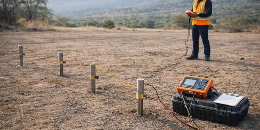
A lot of developers in Frisco guess at the subsurface and end up with surprises during excavation—isolated sand lenses, wet clay seams, or bedrock that sits higher than expected. We see this all the time in Collin County. Electrical resistivity testing cuts through the guesswork. By running a Vertical Electrical Sounding (VES) survey, you get a clear resistivity profile that separates expansive clays from silty layers and water-bearing zones. Our team applies ASTM D6431-18 for field data collection and processes the results with inversion software to match local geology. When you need to plan foundations across a 10-acre tract north of the Dallas North Tollway, you want to know what is underground before the first shovel hits the ground. Combining VES with a CPT test gives you a continuous geotechnical cross-section without relying only on scattered borings.
The Blackland Prairie clays read below 15 ohm-m on a resistivity log, while sands and silts jump above 50 ohm-m—that contrast maps your bearing layer without extra borings.
Local geotechnical context
A mixed-use development off US 380 had three exploratory borings spaced 200 feet apart, all hitting competent shale at 18 feet. The contractor bid based on that. During mass excavation, a 40-foot-wide paleochannel filled with soft organic silt showed up right between two borings. Resistivity would have caught it. The silt body read 8 ohm-m while the surrounding weathered shale sat over 30 ohm-m. The missed feature cost the owner six weeks of over-excavation and select fill replacement, plus a revised foundation design that pushed column loads to deep footings. In Frisco, where the Trinity River tributaries have reworked the near-surface sediments over thousands of years, such buried channels are not rare. Running a VES grid across the pad area—not just spot borings—gives you a continuous image of the subsurface and lets you price the earthwork risk before you mobilize equipment.
Quick answers
What depth can a VES survey reach in Frisco soils?
With the Schlumberger array and maximum current electrode spacing of 600 feet, we typically achieve an investigation depth of 100 to 120 feet below ground surface in the Blackland Prairie clays. Actual depth depends on site access and the resistivity contrast between layers. That range covers the weathered shale interface and any perched water zones relevant to foundation engineering.
How much does an electrical resistivity survey cost in Frisco?
A typical VES survey in the Frisco area runs between US$580 and US$920 per sounding location, depending on the number of stations, maximum electrode spread, and terrain conditions. A full grid survey for a commercial lot with 10 to 15 soundings will fall within that range per station, with volume pricing available for larger tracts.
Can resistivity tell the difference between expansive clay and shale bedrock?
Yes, and that is exactly why we use it here. The Taylor Marl and weathered Eagle Ford clays in Frisco read low—typically 5 to 15 ohm-m—because they hold moisture and have high cation exchange capacity. Competent, less-weathered shale sits higher, often above 25 ohm-m. The resistivity curve shows a clear inflection at the transition, which we ground-truth against available boring logs to set your bearing stratum elevation.
How quickly can I get results from a VES survey?
Field work for a standard grid of 10 to 15 VES stations takes one to two days on site. Data processing, 1D inversion, and interpretation run another two to three business days. You will have a draft resistivity profile and interpreted stratigraphy within a week, assuming dry weather—wet clay conditions slow field mobility but do not affect data quality.